December 29, 2014
Written in honor of Tim Corcoran, Bennington’s Town Clerk
who died in November
 Town Hall walls are filled with maps from different eras showing
many aspects of the Bennington. The maps in the Town Clerk’s office are not
fixed. Tim moved them around. He knew them. He shared them. A copy of the 1835
Hinsdill map sat in front of the fireplace by Tim’s desk for a long time. Then
it migrated over to the door.
Town Hall walls are filled with maps from different eras showing
many aspects of the Bennington. The maps in the Town Clerk’s office are not
fixed. Tim moved them around. He knew them. He shared them. A copy of the 1835
Hinsdill map sat in front of the fireplace by Tim’s desk for a long time. Then
it migrated over to the door.
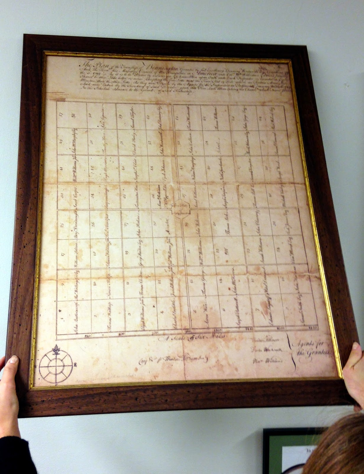
I asked Tim which was the oldest. He said the map on the
wall in the lobby. The photograph is
this map. The hands holding it are those of Cassandra Barbeau, Tim’s Assistant
Clerk, now our Town Clerk.
It is not what I hoped Tim would show me. I wanted a map, c.
1770, that showed early settlement patterns. I wanted early roads, bridges, dams,
paths across the mountains, the way to the next town.
Instead the oldest map is just rectangles, a grid. It has no interest in the actual place.
Benning Wentworth, Royal Governor of New Hampshire, made the map in 1749,
naming us after himself: Bennington. He was never here. He had those boxes neatly
drawn so he could sell the acreage they represented to his cronies. His cronies bought deeds to land they never
saw and sold the deeds to their cronies. Everyone made money. No one came. Eventually
people who did want to live here bought the deeds. They arrived in 1761.
The grid ignores our topography. The Walloomsac and its tributaries
cut diagonally across the Town. We have hills, valleys, water courses, the
Green Mountains, Mt Anthony and Whipstock Hill.
I assumed the grid was so awkward that it disappeared. Even
though Tim said it was our oldest map, I considered it irrelevant.
However I kept driving down very straight roads.
Were they the remnants of grid lines?
 On the back of the Hinsdill map in the Town Clerk’s Office I
found glued a study map; Bennington in 1785. Drawn by unidentified researchers about 1975, it lays
out the lots and owners of record in 1785. Showing how the land was divided 25
years after the first settlers arrived, it confirms that paths did develop on some
of the imaginary lines laid out by Benning Wentworth.
On the back of the Hinsdill map in the Town Clerk’s Office I
found glued a study map; Bennington in 1785. Drawn by unidentified researchers about 1975, it lays
out the lots and owners of record in 1785. Showing how the land was divided 25
years after the first settlers arrived, it confirms that paths did develop on some
of the imaginary lines laid out by Benning Wentworth.
Starting on the east side of town, here are the roads that
began as boundaries between parcels:
Chapel Road, Coleville Road but not East or South Stream
Roads;
Fuller Road, both ends;
N.
Branch Street and Country Road, bordering the Branch family land;
Rice
and Mattison Roads;
some sections of Monument Avenue, North and
South Streets, and Harwood Hill;
Murphy
Road, including the sharp turn on the east end which follows the Hinsdill and Walbridge
boundary;
Austin Hill Road;
West Street and Knapp Road in N. Bennington:
boundary for the Colvins and Halls;
the western ends of Vail and Walloomsac Roads,
Houran Road.
A copy of the 'Bennington in 1785' map is also available for study at the Bennington Museum library.
A copy of the 'Bennington in 1785' map is also available for study at the Bennington Museum library.
Note:
I date the study map from the hand written notes - ie before wide spread use of computers and copiers. By the mid 1980's labels could have been typed and pasted to the map.
However, perhaps the research was done for Bennington's 200th anniversary, 1961. or its 225th, 1986.
I hope this column will bring forth someone who knows so I can give proper credit and thanks to those who produced the study map.
No comments:
Post a Comment